Imprescindibles
Más vendidos Libros más leídos eBooks más leídos Todos los libros Todos los libros Autores destacados Series y sagas
Recomendados Libros recomendados Autores destacados Libros que inspiran Vidas con historia LGTBIQ+ English books


Ficción
Literatura Contemporánea Estudios literarios Clásicos Cuentos Poesía Teatro Libros de bolsillo Sagas literarias
Géneros literarios Novela romántica y erótica Novela negra Novela histórica Narrativa fantástica Novela de ciencia ficción Novela de terror Narrativa de humor Narrativa de viajes
Literatura en otros idiomas Literatura en inglés Literatura en francés Literatura en otros idiomas internacionales

No Ficción
Ciencias y tecnología Biología Ciencias Ciencias naturales Divulgación científica Informática Ingeniería Matemáticas Medicina Salud y dietas Formación Idiomas Estilo de vida Libros de Cocina Guías de viaje Narrativa de viajes Deportes Libros de Juegos Manualidades
Humanidades Autoayuda y espiritualidad Ciencias humanas Derecho Economía y Empresa Psicología y Pedagogía Filosofía Sociología Filología Biblioteconomía Estudios filológicos Estudios lingüísticos Estudios literarios Historia y crítica de la Literatura


Infantil


Juvenil
#Jóvenes lectores Narrativa juvenil Clásicos adaptados Libros Wattpad Libros Booktok Libros de influencers Libros de Youtubers Libros Spicy Juveniles Libros LGTBIQ+ Temas sociales Libros ciencia ficción Libros de acción y aventura Cómic y Manga Juvenil Cómic Juvenil Manga Shonen Manga Shojo Autores destacados Jennifer L. Armentrout Eloy Moreno Nerea Llanes Hannah Nicole Maehrer
Libros de fantasía Cozy Fantasy Dark academia Hadas y Fae Romantasy Royal Fantasy Urban Fantasy Vampiros y hombres lobo Otros Misterio y terror Cozy mistery Policiaca Spooky Terror Thriller y suspense Otros
Libros románticos y de amor Dark Romance Clean Romance Cowboy Romance Mafia y amor Romance dramatico Romcom Sport Romance Otros Clichés Enemies to Lovers Friends to Lovers Hermanastros Slow Burn Fake Dating Triángulo amoroso

Cómic y Manga
Novela gráfica Novela gráfica americana Novela gráfica europea Novela gráfica de otros países Personajes, series y sagas Series y sagas Star Wars Superhéroes Cómics DC Cómics Marvel Cómics otros superhéroes Cómics Valiant
Cómics Libros de ilustración Cómic de humor Cómic erótico Historia y técnica del cómic Cómic infantil y juvenil Cómic infantil Cómic juvenil


Books in English 
Books in English Fiction Non Fiction Comic Teen & Young Adult Main Authors Ken Follett Agatha Christie Stephen King Jane Austen Maggie O’Farrell On sale
Books in English for Young Adults Age 13+ Age 15+ Young Adult Authors Rebecca Yarros Sarah J. Maas Brandon Sanderson Ali Hazelwood Alice Oseman


The Secrets Of Secrets
A thrilling and long-awaited new novel from Dan Brown
Audiolibros
Literatura Contemporánea Narrativa fantástica Novela de ciencia ficción Novela de terror Novela histórica Novela negra Novela romántica y erótica Historia Historia universal
Humanidades Autoayuda y espiritualidad Ciencias humanas Economía y empresa Psicología y pedagogía Filosofía Infantil Audiolibros infantiles
Ciencia y tecnología Ciencias naturales Divulgación científica Medicina Salud y dietas Arte Cine Música Historia del arte
eBooks
Literatura Contemporánea Narrativa fantástica Novela de ciencia ficción Novela de terror Novela histórica Novela negra Novela romántica y erótica Juvenil Más de 13 años Más de 15 años Infantil eBooks infantiles
Humanidades Autoayuda y espiritualidad Ciencias humanas Economía y Empresa Psicología y Pedagogía Filosofía Historia Historia de España Historia Universal Arte Cine Música Historia del arte
Ciencia y tecnología Ciencias naturales Divulgación científica Medicina Salud y dietas Filología Estudios lingüísticos Estudios literarios Historia y crítica de la Literatura Estilo de vida Cocina Guías de viaje Ocio y deportes


Novedades del último mes en libros de Geografía
Categorias
Filtros
Del 1 al 5 de 5

UNIVERSIDAD DE VALLADOLID. SECRETARIADO DE PUBLICACIONES E I 9788413203850
En estos años se cumplen 450 años de la publicación del libro de vistas de ciudades titulado Civitates Orbis Terrarum. De ahí que en la obra que les presento hago una comparación histórica, artística y literaria entre las ciudades del siglo XVI y los perfiles urbanos actuales a traves de textos e imagenes que pueden ser fotografias o acuarelas. Partimos de una introduccion sobre el paso de la percepcion frontal del paisaje en la Edad Moderna a la percepcion vertical que tenemos en el mundo contemporaneo. A continuacion, damos una pincelada interdisciplinar de cada una de las ciudades seleccionadas -unas por figurar en el Civitates y otras por encarnar la modernidad- acompañadas de una ilustracion. Y concluimos con la evolucion de los panoramas de espectac ...
Ver más
Tapa blanda
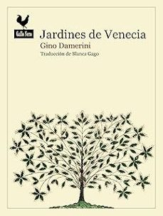
DAMERINI, GINO
Gallo Nero Ediciones 9788419168849
«Lo cierto es que ningún paseo público en el mundo ofrecía perspectivas, silencios y seducciones panorámicas comparables a las perspectivas, los silencios y las seducciones ofrecidas, como una noveda
Ver más
Tapa blanda
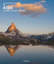
BERNHART, UDO
KÖNEMANN 9783741936470
Una vasta cadena montañosa que se extiende de oeste a este por siete países y forma una barrera de roca, nieve y hielo en medio de Europa. Este libro ilustrado muestra la diversidad paisajística y la belleza de los Alpes, que cuentan con mas de 100 picos de trece mil metros, una rica flora y fauna, lugares muy dignos de ver y costumbres conservadas con cariño.---"Ein riesiges Gebirge, das sich von Westen nach Osten uber sieben Lander erstreckt, bildet eine Barriere aus Fels, Schnee und Eis in der Mitte Europas. Dieser Bildband zeigt die landschaftliche Vielfalt und Schonheit der Alpen mit uber 100 Dreizehntausendern, einer reichen Flora und Fauna, sehr sehenswerten Orten und liebevoll gepflegten Brauchen."---A vast mountain range stretching from west to east over seven countries forms a barrier of rock, snow and ice in the middle of Europe. This illustrated book shows the scenic diversity and beauty of the Alps which has over 100 thirteen-thousand-foot peaks, a rich flora and fauna, places very much worth seeing and lovingly preserved customs.
Ver más
Tapa dura
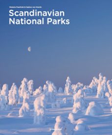
PAWLITZKI, MELANIE
KÖNEMANN 9783741936548
Desde el Parque Nacional de Vatnajokull, en Islandia, con su fascinante glaciar, pasando por el Parque Nacional de Nordre-Isfjorden, en Noruega, en el extremo norte, hasta el Parque Nacional del Mar de Wadden, en Dinamarca: los parques nacionales escandinavos no podrian ser mas diversos. Pero hay algo que tienen en comun: inspiran a todo el mundo. 400 fotos espectaculares muestran la belleza de la naturaleza escandinava.---"Vom islandischen Vatnajokull-Nationalpark mit seinem faszinierenden Gletscher uber den norwegischen Nationalpark Nordre-Isfjorden im hohen Norden bis hin zum danischen Wattenmeer-Nationalpark - die skandinavischen Nationalparks konnten kaum vielfaltiger sein. Aber eines haben sie gemeinsam: Sie inspirieren alle. 400 spektakulare Fotos zeigen die Schonheit der skandinavischen Natur."---From Iceland's Vatnajokull National Park with its fascinating glacier, Norway's Nordre-Isfjorden National Park in the far north, to Denmark's Wadden Sea National Park the Scandinavian national parks could hardly be more diverse. But one thing they have in common, they inspire everyone. 400 spectacular photos show the beauty of Scandinavian nature.
Ver más
Tapa dura

Errata Naturae Editores 9791387597344
Tras perder a los dos grandes amores de su vida, ver fracasar la Comuna de París y huir para salvarse de la ejecución, Reclus tocó fondo y encontró en la montaña un refugio físico y espiritual. En este clasico de culto, el gran geografo y militante anarquista convierte su experiencia en una poderosa reflexion sobre lo que las montañas han sido, son y seran para la humanidad. Asi, combinando el conocimiento cientifico, la erudicion humanista y su experiencia personal como montañero, nos habla del origen geologico de las montañas, sus ecosistemas amenazados, sus leyendas y dioses, los pueblos que las habitan, su flora y su fauna, asi como las ascensiones del autor entre glaciares, tormentas y desfiladeros. Un clasico indispensable de la nature writing.
Ver más
Tapa blanda
Del 1 al 5 de 5